
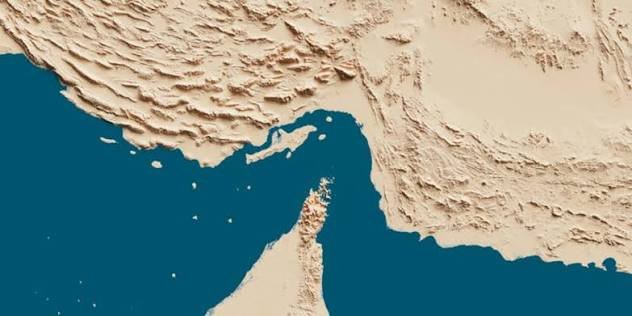

The Strait of Hormuz map provides an important geographical view of one of the world’s most strategically significant waterways. Located between Iran and the Musandam Peninsula of Oman, this narrow passage connects the Persian Gulf with the Gulf of Oman and the Arabian Sea. Although relatively small compared with major oceans, the strait plays an enormous role in international shipping, energy transportation, and global trade.
Understanding its location helps explain why governments, energy companies, shipping organizations, and international observers pay close attention to developments in this region. Its geographical position makes it a critical connection between major oil-producing countries and international markets.
Where Is the Strait of Hormuz Located?
The Strait of Hormuz is situated in the Middle East, between southern Iran and the northern coast of Oman. It forms the only direct maritime entrance and exit between the Persian Gulf and the open waters of the Gulf of Oman.
Looking at a regional map, the strait can be found near several important Gulf countries, including the United Arab Emirates, Saudi Arabia, Qatar, Bahrain, Kuwait, and Iraq. These countries depend on the surrounding maritime network for international commerce and energy transportation.
Iran lies along the northern side of the waterway, while Oman’s Musandam Peninsula forms much of its southern boundary. The United Arab Emirates is also located close to the southern approaches.
Its geographical position makes the passage particularly important because ships transporting energy products from the Persian Gulf must normally travel through this narrow maritime connection to reach international destinations.
Understanding the Strait of Hormuz Map
A detailed map of the Strait of Hormuz shows more than a narrow stretch of blue water between two coastlines. It illustrates surrounding countries, islands, ports, shipping channels, and important geographical features.
One of the most noticeable features is the waterway’s narrowest section, which measures approximately 21 nautical miles, or 39 kilometres, across.
However, the entire width is not available for unrestricted commercial navigation. International shipping follows designated traffic separation arrangements that organize vessels moving in opposite directions.
These arrangements are particularly important because large oil tankers, cargo ships, and other commercial vessels regularly use the passage.
A useful map should clearly identify Iran, Oman, the Musandam Peninsula, the Persian Gulf, the Gulf of Oman, and the nearby islands.
Countries Surrounding the Strait
Several countries have important geographical and economic connections to this waterway. Their proximity explains why the region receives considerable international attention.
Iran
Iran occupies the northern coastline and has a significant geographical presence around the strait. Several Iranian islands, including Qeshm, Larak, and Hormuz, are located in or near the waterway.
These islands are important geographical reference points when studying regional maritime routes and coastal navigation.
Oman
Oman controls the Musandam Peninsula, which extends toward the southern side of the strait. This location gives Oman an important position along the maritime entrance to the Persian Gulf.
The peninsula is especially recognizable on regional maps because of its distinctive shape and mountainous coastline.
United Arab Emirates
The UAE lies southeast of the strait and has several important commercial ports. Fujairah, located outside the Strait of Hormuz on the Gulf of Oman, is particularly significant because it provides an alternative shipping location for certain energy exports.
Other Gulf Countries
Saudi Arabia, Qatar, Bahrain, Kuwait, and Iraq are also closely connected to the waterway through their geographical position and energy industries.
Although these countries do not all share a coastline with the strait itself, their exports and imports depend heavily on maritime routes passing through it.
Why Is the Strait of Hormuz So Important?
The importance of the waterway comes primarily from its role in international energy transportation.
The International Energy Agency reported that approximately 20 million barrels per day of crude oil and petroleum products passed through the strait in 2025. This represented around one-quarter of global seaborne oil trade.
That figure demonstrates why even a temporary disruption can create serious consequences for international markets.
Countries such as Saudi Arabia, Iraq, Kuwait, Iran, and the United Arab Emirates use the wider Persian Gulf shipping network to transport energy products to customers around the world.
Natural gas transportation is another important part of its economic significance. Qatar, one of the world’s leading liquefied natural gas exporters, depends on maritime access through this region.
Consequently, the Strait of Hormuz is not simply a regional geographical feature. It is an essential part of the international energy supply system.
Major Shipping Routes and Navigation Channels
The Strait of Hormuz map also helps explain how commercial vessels navigate through a relatively narrow maritime passage.
The International Maritime Organization established a Traffic Separation Scheme for the strait to organize vessel movements and reduce the possibility of collisions.
The arrangement includes designated inbound and outbound shipping lanes, each approximately two nautical miles wide, with a separation zone between them.
Large tankers and commercial cargo vessels follow these designated routes when navigating between the Persian Gulf and the Gulf of Oman.
The shipping lanes are particularly important because the region handles vessels of different sizes and types. Without organized navigation arrangements, managing such concentrated maritime traffic would become significantly more difficult.
The nearby islands and coastal features also provide important geographical reference points for understanding the passage.
Important Islands Near the Strait
Several islands appear prominently on detailed regional maps and contribute to the geographical importance of the waterway.
Qeshm is the largest island in the Persian Gulf and is located close to Iran’s southern coastline. Its position makes it an important reference point when studying the northern approaches to the strait.
Hormuz Island lies farther east and is known for its distinctive geological landscape and colourful soil formations.
Larak Island is another important geographical feature situated near the main maritime passage.
On the southern side, the Musandam Peninsula provides a recognizable natural boundary between the Persian Gulf entrance and the Gulf of Oman.
Together, these geographical features help explain the physical layout of this strategically important region.
Strait of Hormuz and Recent International Tensions
The strategic importance of the strait has become particularly visible during periods of regional conflict.
In 2026, tensions involving Iran, the United States, and other regional actors significantly affected commercial shipping and maritime security.
The International Maritime Organization reported in August 2026 that thousands of seafarers had been affected by the ongoing crisis. Its statements also highlighted attacks against commercial vessels and the difficulties faced by ships operating in the region.
More recent reporting in November 2026 has continued to describe incidents involving commercial shipping and heightened security concerns.
These developments demonstrate why geographical knowledge of the Strait of Hormuz is important when following international news.
However, a geographical map should not be confused with a live maritime security report. Shipping restrictions, vessel movements, and navigational conditions can change quickly. Historical maps cannot confirm whether a particular route is currently safe or available.
How to Read a Strait of Hormuz Map
Reading a map of this region becomes easier when you understand its main geographical elements.
Start by locating Iran on the northern side and Oman on the southern side. The narrow passage between them represents the Strait of Hormuz.
Next, identify the Persian Gulf to the west and the Gulf of Oman to the east. These two bodies of water are connected through the strait.
Look for nearby islands, particularly Qeshm, Larak, and Hormuz. Their positions help establish a clearer understanding of the surrounding coastline.
Finally, examine the shipping lanes and nearby ports. These features explain how international vessels connect Gulf energy producers with destinations across Asia, Europe, and other international markets.
A political map is useful for identifying national boundaries, while a nautical chart provides more detailed information about water depths, navigation channels, and maritime hazards.
Economic Impact on Global Trade
Disruptions in the Strait of Hormuz can influence much more than the energy industry.
When shipping becomes difficult, oil and gas transportation costs can increase. Insurance companies may raise premiums for vessels operating in high-risk waters, while shipping companies may reconsider their routes and schedules.
These additional expenses can eventually affect energy prices, manufacturing costs, transportation, and consumer markets.
Countries that import large quantities of oil and natural gas are particularly exposed to disruptions in the region.
Although alternative pipelines and export terminals exist, their available capacity cannot necessarily replace all the shipments that normally travel through the strait.
This limited flexibility explains why the waterway remains one of the most closely watched maritime chokepoints in the international economy.
Conclusion
The Strait of Hormuz map offers a clear understanding of a waterway whose importance extends far beyond its physical size. Connecting the Persian Gulf with the Gulf of Oman, it provides an essential maritime route for energy exports, international shipping, and regional commerce.
Its location between Iran and Oman, its nearby islands, and its carefully organized shipping channels make it geographically and strategically significant.
For anyone following international trade, energy markets, or Middle Eastern affairs, understanding this region provides valuable context. The Strait of Hormuz remains a critical connection between Gulf-producing countries and the wider world, making its geographical position important to international economic stability.
Frequently Asked Questions
Where is the Strait of Hormuz located?
The Strait of Hormuz is located between southern Iran and Oman’s Musandam Peninsula. It connects the Persian Gulf with the Gulf of Oman.
Which countries border the Strait of Hormuz?
Iran and Oman are the two countries directly bordering the main waterway. The United Arab Emirates is also located close to its southern approaches.
How wide is the Strait of Hormuz?
At its narrowest point, the strait is approximately 21 nautical miles, or 39 kilometres, wide.
Why is the Strait of Hormuz important?
It is a major international energy transportation route. Millions of barrels of crude oil and petroleum products pass through it, making it essential to global energy supplies.
Which islands are located near the Strait of Hormuz?
Important nearby islands include Qeshm, Larak, and Hormuz. These islands are particularly useful geographical reference points when studying the region.
Does the Strait of Hormuz connect two seas?
The strait connects the Persian Gulf with the Gulf of Oman. The Gulf of Oman then opens into the Arabian Sea and the wider Indian Ocean.
Is the Strait of Hormuz open to commercial ships?
Its operating conditions have been severely affected by regional tensions in 2026. Commercial access, security restrictions, and vessel movements can change, so current maritime information should be checked before drawing conclusions about its availability.